
 |
|
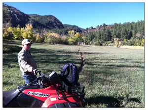
In the early 1990s, the U.S. Forest Service purchased 1,500 acres in Hidden Valley off County Road 205 called the Falls Creek Archaeological Area with federal and private funds./Photo by Tracy Chamberlin
|
Coming up with a plan
Forest Service, local landowner see the future through the trees
by Tracy Chamberlin
One has taken almost a decade. Another is at five years … and counting. Whether it’s a 30-acre parcel outside Durango or 1.8 million acres stretching across Southwest Colorado, it’s all about having a plan.
This September the wait ended for one of those plans, the San Juan National Forest Land and Resource Management Plan, which deals with the future of millions of acres of public lands and replaces an outdated document from 1983.
Released jointly by the San Juan National Forest and Bureau of Land Management Tres Rios Field Office, the plan lays out guidelines for overall forest management, recommends specific areas for wilderness and Wild and Scenic River designations, offers strategies for dealing with climate change, and attempts to address oil and gas development.
“This has been a long process that has required a great deal of effort on the part of agency personnel, the public and others,” said Mark Stiles, San Juan National Forest Supervisor, in a news release.
As government officials and the public begin to sift through the thousand-plus pages, some have expressed relief that the plan has finally reached the finished line. Others have conveyed concerns that perhaps it doesn’t address some key issues facing the area in the days and years ahead.
|
It’s official … After years of meetings, comments, feedback, drafts and revisions, the San Juan National Forest Land and Resource Management Plan is ready for prime time. To view the document, visit www.fs.usda.gov/main/sanjuan/landmanagement/planning. |
"We were hoping for a more visionary, forward-thinking document,” said Jimbo Buickerood, public lands coordinator for the San Juan Citizens Alliance.
He added that the release of the final plan is certainly a relief to those involved in its development and that it’s important to have a direction for the next 15 to 20 years, but there are some misses.
As for the hits, Buickerood pointed out two positives.
“One great addition is the section on climate change, which does look forward,” he added. The framework on that issue focuses on mitigation efforts and having adaptable practices.
Another plus for Buickerood is the addition of nine new research natural areas. Officials selected a variety of forest landscapes to examine.
These spaces are like snapshots of the natural forest process, and can help guide management decisions for similar areas. “It’s a really good baseline to see what’s going on,” Buickerood said.
The plan also includes Wild and Scenic River recommendations. This designation requires an act of Congress, but the recommendation is the essential first step for consideration.
One of the downsides of the plan, according to Buickerood, is the decrease from the draft plan released in 2007 in the amount of acres recommended for wilderness designation.
“We find that to be unfortunate,” he said. “Nationally and in this state, the wilderness is underrepresented as far as lower elevation.”
Another downside is that some issues were passed over. Although the plan covers almost 2,000 pages, Buickerood said some issues were simply not addressed like the Gothic Shale Play in Dolores and Montezuma counties and the suggestion of a master leasing plan for oil and gas leases.
The Forest Service admits that the actual acreage available for oil and gas leasing hasn’t changed significantly from the 1983 plan. It does, however, state in a press release that the updated plan institutes new stipulations, affecting the future of oil and gas development.
With private lives being so intertwined with public lands, the direction federal agencies take eventually affects most residents.
“Between the Forest Service and Bureau of Land Management, we’re talking about two and a half million acres,” Buickerood said. “And, most of us live next to it … we’ll come across (the plan) soon enough.”
Local landowner Ed Zink, who owns a ranch as well as a downtown business, is an example of that relationship between locals and public lands.
In the early 1990s, the Forest Service purchased 1,500 acres in Hidden Valley called the Falls Creek Archaeological Area with federal and private funds.
Zink’s father even sent letters to his local congressman and senator in support of the land purchase.
After those lands were purchased, the Forest Service adopted an amendment to the 1983 management plan that laid out how officials intended to manage the Hidden Valley area. Those intentions are also included in the updated version.
A 30-acre parcel Zink owns is adjacent to the Falls Creek Archaeological Area. It’s been in the Zink family since his grandfather first purchased it in 1917.
The property, located in Hidden Valley near the Falls Creek neighborhood, sits between county roads 205 and 203 and was once accessed by crossing over the land owned by a neighboring rancher. That’s not the case any longer.
These days, Zink must trek across the properties of several different private landowners or over Forest Service lands on an all-terrain vehicle in order to reach it.
What he really needs is a road. And there are two options leading the discussion.
A proposed access road from County Road 205, otherwise known as Falls Creek Road, runs about a half mile long with an elevation change of about 50 feet. Access from County Road 203, on the other hand, would be about three-quarters of a mile long and involve an elevation change of around 500 feet, including gradients as high as 30 percent in some sections.
The 205 access option crosses the Forest Service lands purchased in the 1990s, and the 203 access crosses the private lands, owned by five separate parties.
As for building a road from 203, Zink said he’s talked to the property owners and received essentially a “No thank you,” response.
Even if he had the go-ahead from those property owners, Zink said accessing the parcel from 203 would leave an “environmental scar” that development from 205 would not.
Zink owns about 150 acres in the valley, 120 of which is in conservation easement. Also, serving his third term as the chair of the city’s Natural Lands Preservation Advisory Board, he’s no stranger to land conservation.
He said he believes the 205 option is the best one.
The application process for accessing his property, like the Forest Service plan, is lengthy with several steps along the way including a scoping period, possible environmental assessments and public commenting periods.
And, Zink said he’s comfortable with the process.
He first filed the application five years ago in 2008. The reason he applied was because he wanted to have a plan. Knowing that the days when one could walk across the neighbor’s ranch were in the past, he started the paperwork.
“I’m not going to leave unfinished things for my kids,” he said.
In this week's issue...
- June 4, 2026
- Tougher on trash
As human-bear conflicts rise, new state law targets ‘knowingly’ allowing attractants
- June 4, 2026
- Redefining the business of art
Colorado’s new A Corp model helps creatives retain control while attracting investment
- May 28, 2026
- Quick 'n' Dirty
Help for the Demon Bridge, Highway 550 N closure, and fire mitigation falls off