|
| ||||
| Reining in ATV abuse SideStory: Protecting Utah's Red Rock Wilderness
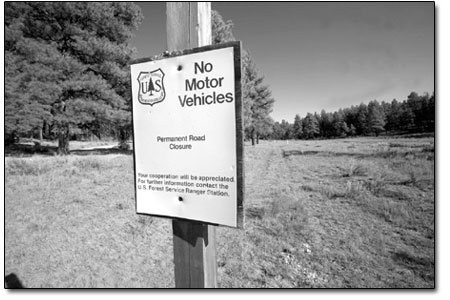
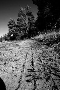
by Missy Votel The San Juan National Forest is continuing its effort to put the brakes on cross country ATV use. Last week, the columbine Ranger District began accepting comments on its Draft Environmental Analysis for motorized travel on public lands in the HD Mountains, west of Bayfield. Referred to as the Beaver Meadows-Saul’s Creek Landscape, the area comprises more than 80,000 acres of public lands overseen by the Forest Service and Bureau of Land Management. The Saul’s Creek landscape is the second area to be analyzed by the district in light of 2005’s Travel Management Rule, a federal mandate to rein in ATV abuses on public lands. The Lakes area, made up of public lands surrounding the Vallecito and Lemon reservoir areas, was the first local landscape under the rule to get a travel management plan, which was completed late in the summer of 2008. With the recent boom in ATV use and popularity, Cooley said there has also been a sharp increase in resource damage on public lands, locally and across the country. Among myriad concerns are those over cultural site damage, erosion, wildlife habitat damage and fragmentation, spread of noxious weed and user conflict. Cooley estimated there are about 100 miles of user-created and official Forest Service trails and roads in the Saul’s Creek landscape. “It’s a spaghetti network, and we’re seeing problems with resource damage,” she said. The Forest Service’s four alternatives range from the requisite “no action” to “minimum” motorized opportunities on current Forest Service trails and roads only, to “maximum” motor opportunities on existing routes as well as some user created ones as well “Alternatives 3 and 4 would designate about 52 miles to motorized use,” she said. The designation would apply only to vehicles 50 inches wide and smaller.
Veronica Egan, executive director of the Durango-based Great old Broads for Wilderness, said she is eager to see a crack down on free-rein motorized use in the Saul’s Creek area. “It definitely needs serious management, including serious enforcement and serious penalties,” she said. In addition to causing resource and habitat damage, she also pointed out that roughshod ORV travel also results in an increase in airborne dust, which has been implicated in early snowmelt and run off. “I think everyone became more aware of that problem this spring.” Egan said central to any travel management plan is the ability to enforce it. “If there’s nothing to enforce cross country travel other than an idea, it will require more on-the-ground management,” she said Egan said The Lakes area, which has 52 miles designated for off-road vehicle use, is the perfect example of a plan without teeth. “It’s still a mess up there,” she said of the area north of Durango, which is being monitored by a team of conservationists. “There are no signs up there, and no one knows where they can and can’t go.” Cooley said there is some signage up in The Lakes area and the rest should be erected by the end of next summer. Although there is one ranger responsible for policing the area for off-highway vehicle infractions, she said there are numerous Forest Service employees who have been trained as forest protection officers and patrol the area regularly. “We have what we call ‘FPOs,’ who are regular Forest Service employees who can issue citations on the ground,” she said. To further enforcement efforts, she said the Forest Service will be releasing a Motor Vehicle Use Map at the end of the year that will detail approved routes throughout the entire forest. “It will cover the whole forest and be an enforcement tool for motorized routes,” she said. After Saul’s Creek, San Juan Public Lands will move onto the La Plata Mountains landscape, which has a whole set of problems all its own. “La Plata Canyon is about the only place that’s got some wide, open area for cross country travel,” Cooley said. Comments on the Beaver Meadows-Saul’s Creek Travel Management Plan will be accepted through Oct. 19 and can be mailed to: Nancy Berry, Project Leader, Columbine Ranger District, P.O. 439, 367 S. Pearl St., Bayfield, CO, 81122 or faxed: Attn: Nancy Berry, 884-2428. To view the draft ea online, go to http://www.fs.fed.us/r2/sanjuan/ projects/projects.shtml and scroll down to the “New 9/16/09” heading and click on the “draft environmental assessment” link. •
|
The Independent Weekly Line on Durango and Beyond