
| ||||
| The wilderness riddle Preservation and recreation at odds in Hermosa Creek SideStory: Wild San Juans: Conservation group forwards wilderness candidates
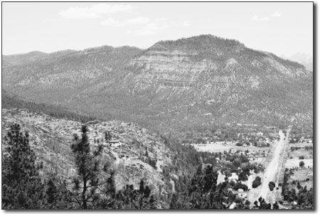
by Will Sands Big changes are in store for the landscape surrounding Durango. The forthcoming revision of the San Juan National Forest Plan is expected to have far-reaching impacts, and there is at least one area where recreation and preservation could clash. Conservationists are advocating the creation • of a West Hermosa Creek Wilderness Area, but trail users have serious reservations. The management of the San Juan National Forest’s nearly 2 million acres is guided by a forest plan that has been in place since 1983, and there is widespread agreement that the plan is hopelessly outdated. Over the last several years, the San Juan Public Lands Center has undertaken a revision and reassessed the guiding principles of the San Juan National Forest. As part of any revision, roadless areas must be considered for recommendation as potential wilderness areas. Wilderness designation would provide exceptional protection but also limit mechanized travel, including mountain bike recreation. Far and away the largest roadless area in the San Juan National Forest surrounds Hermosa Creek, northwest of Durango. The 145,000-acre area is also home to the Hermosa Creek Trail, revered by mountain bikers throughout the nation, as well as nearly 10 other trails, including Jones Creek, Dutch Creek, Pinkerton-Flagstaff and Corral Draw, which attract both mechanized and nonmechanized trail users. Nonetheless, the roadless area’s size and pristine quality make it a strong candidate for wilderness designation, according to Thurman Wilson, assistant manager of the San Juan Public Lands Center. “What we’re doing is evaluating the roadless areas on the forest and trying to determine which ones meet the minimum criteria for wilderness,” Wilson said. “The Hermosa Creek Roadless Area certainly meets the eligibility requirements.” Still, the Forest Service has not settled on its recommendation for the Hermosa Creek area, and Wilson noted that the agency is taking input from both sides. “There’s certainly a big mix of ideas on how to manage it,” he said. “I don’t think there are any advocates for putting roads in there, but there’s definitely a group of people advocating wilderness designation. There’s also a group pushing for us to manage it as it is now.” Two conservation organizations, San Juan Citizens Alliance and the Sierra Club, definitely see value in creating a Hermosa Creek Wilderness Area. “It’s a very pristine and remote part of the forest,” commented Mark Pearson, executive director of SJCA. “It also has a very different ecosystem than the rest of the wilderness areas on the forest since it’s a lower-elevation, mixed-conifer forest.” Jim Sumrall, chair of the Weminuche Chapter of the Sierra Club, noted that wilderness designation would take an already pristine area and enhance its environmental qualities.
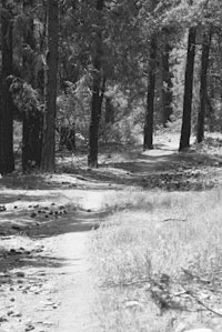
“This would go beyond maintaining its current 4 condition,” Sumrall said. “We’ve seen that areas that have been logged and mined begin to recover after being designated as wilderness. Given a chance, the land will go back to its natural state.” However, Pearson and Sumrall also acknowledged that the Hermosa Creek Roadless Area is prized for more than its natural qualities. “The main drawback to designation as wilderness is that the Hermosa Creek area is currently used by trail bikes,” Sumrall said. “You wouldn’t be able to take bikes in there, but you’d still be able to hike and travel by horseback.” San Juan Citizens Alliance has also recognized the recreational value of the Hermosa Creek Trail and much of the roadless area. As a result, the group is forwarding a proposal to designate only the lands west of Hermosa Creek as wilderness and leave the rest as a bike-friendly roadless area. “We’ve recognized that the trail is such a popular mechanized route that it’s really not feasible to designate the entire area as wilderness,” Pearson said. “So, we’ve really been focusing on the west side of the drainage for wilderness.” Nonetheless, many object to wilderness in any part of the Hermosa Creek Roadless Area. Although they see lighter use, the West Hermosa area still contains the Clear Creek, South Fork and Corral Draw trails, and wilderness would effectively close them to mountain bikes. “The entire Hermosa Creek area is a widely used recreation area,” said Mary Monroe, executive director of Trails 2000. “Sure, you have the Hermosa Creek Trail, but mountain bikers, hikers and horseback riders use the vast majority of trails up there. It’s important to recognize and honor that use.” The International Mountain Biking Association has long argued in favor of protection tools that do not preclude mountain bikes. A national scenic area or primitive area designation would afford Hermosa Creek better protection but not exclude cyclists as a user group, according to Mark Eller, IMBA communications manager. “A lot people have the impression that IMBA’s universally against wilderness,” he said. “That’s not entirely true. What we’d like is for land managers to look at a wide variety of management tools.” The San Juan National Forest is doing just that, according to Wilson. The agency plans to release a draft forest plan revision in coming months and expects a great deal of dialogue on the Hermosa Creek Roadless Area. “What we’re probably going to have in our draft is that the Hermosa be managed as a primitive area and not be designated as wilderness,” Wilson said. “We’re thinking that the west side of the creek would be closed to motorized, and we’d only allow motorcycles and ATVs on a few of the trails on the east side of the creek But the whole area would still be open to mountain bikes.” The agency will look to the public to weigh-in and shape the draft when it is released in September. •
|
In this week's issue...
- June 4, 2026
- Tougher on trash
As human-bear conflicts rise, new state law targets ‘knowingly’ allowing attractants
- June 4, 2026
- Redefining the business of art
Colorado’s new A Corp model helps creatives retain control while attracting investment
- May 28, 2026
- Quick 'n' Dirty
Help for the Demon Bridge, Highway 550 N closure, and fire mitigation falls off