|
BLM prepares to release final Environmental Impact
Study
by Missy Votel
 |
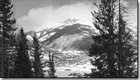
Storm Peak, home to Silverton
Mountain ski area, is seen in this photo last winter. The
final EIS on the ski area’s permit to operate on 1,300
acres of BLM land
is due to be out next month./Photo by Todd Newcomer. |
After more than three years in the environmental planning process,
the Bureau of Land Management is nearing completion of the final
draft environmental impact statement for the Silverton Mountain
ski area.
“Hopefully it will be out in the next month,” said
Richard Speegle, recreation project leader for the BLM. “We’re
working on it every day.”
The extreme ski area has been operating under a temporary permit
on a guided skiing-only basis since 2002. In 1999, Silverton Mountain
owner Aaron Brill submitted a proposal to the BLM to operate an
expert backcountry skiing operation on 350 acres of his land and
1,300 acres of adjacent BLM land about six miles north of Silverton.
He installed a double chairlift on his property, an old mining
claim, in 2001 with visions of creating a powder skier’s
paradise with inexpensive lift tickets and a 475-skier cap.
However, the dream was put on hold when the BLM ordered an environmental
impact statement to assess the full impacts of the ski area. The
draft of the EIS was issued last summer and outlined four alternatives
for operating the ski area, including the preferred alternative
– a mix of guided and unguided skiing. The comment period
on the draft EIS closed Sept. 18.
Speegle said his office received about 50 comments on the draft
EIS, which will be responded to in the final EIS.
“We learned a few things, and there’s some new information
in the final EIS,” he said.
He said the comments centered on three main areas: snow safety,
private land and wildlife.
Brill’s permit area boundary encircles land owned by Jim
Jackson, who at one time proposed a large ski resort for Velocity
Basin. There have been recent allegations that avalanches from
control work and skiers from Silverton Mountain have been crossing
into Jackson’s private property. However, Speegle said Brill
has an agreement with San Juan County to perform control work
to keep county roads 110 and 52 open, and the reports of trespassing
skiers are unfounded.
“Denny Hogan, our snow ranger up there, said he’s
not seeing any guided skiing outside the permit area,” he
said.
Nevertheless, Speegle said settling private land disputes is
not up to the BLM, and Brill and Jackson must come up with an
agreement on their own. “We don’t see that as a BLM
issue,” Speegle said.
The final EIS also will pay particular attention to the existence
of lynx within the permit area, he said.
“There is lynx habitat up there and lynx are in the area,”
he said, adding that the land between Ouray and Durango is considered
a primary corridor for lynx travel. He said the BLM and Forest
Service are consulting with the U.S. Fish and Wildlife on how
to manage the endangered cats.
As far as snow safety goes, Speegle said the BLM was encouraged
by what it witnessed with this winter’s snowfall.
“So far, so good,” he said. “Aaron’s
done a good job with the snow safety.”
Although the EIS has been three years in the making, Speegle
said the timeline is pretty standard for a study as complex as
this. He did say time was lost in the summer of 2002 when the
San Juan Public Lands Center had to redirect energy to fighting
the Missionary Ridge Fire.
Once the final EIS comes out, there will be a 30-day protest
period. Under state law, the state government also has 60 days
to review the EIS and sign off on it as well. From there, the
EIS will go to the state BLM director for approval, and a record
of decision will be issued.
|

