 |
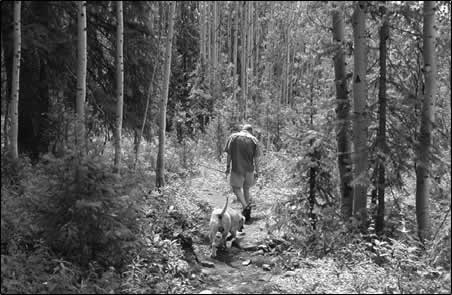
| John Carroll, of Silverton,
and his dog walk one of the countless trails that criss
cross the backcountry in San Juan County. Carroll and
a group called Community Design are in the process of
mapping the former mining trails in the area for use
as a recreational map. Carroll believes the actual number
of trails will be astounding. /Photo by Amy Maestas. |
More than a century of mining in the San Juan Mountains surrounding
Silverton has left more than steel relics and closed-off
adits. Still in place are untold miles of trails that are
often untouched because of a lack of inventory and maps.
But Silverton resident John Carroll, recognizing the value
of the paths miners cut for their Jeeps and mules on public
land, is ready to change that. Recently, Carroll, a landscape
architect who has lived on and off in Silverton for the past
12 years, set in motion a plan to build a database and identify
these trails with the intent of creating a map for recreational
use. The project – the San Juan Trails Initiative – likely
will have far-reaching impacts.
Magazines, including National Geographic, Outside and Skiing,
all have declared the San Juan Mountains to be one of the
top 10 destinations for outdoor adventure. The buzz among
a few Silverton residents is that combined with its existing
popularity and a new spotlight on trails, the tiny settlement
at nearly 10,000 feet will become the “alpine version
of Moab.”
“
I agree,” Carroll says. “All these trails provide
a tremendous recreational opportunity.”
Neither Carroll nor any public-land officials know exactly
how many miles of trails exist in San Juan County. Some recreation
guides estimate there are 750 miles of four-wheel-drive roads
alone. Yet because the county is replete with thousands of
mining claims – all of which have some sort of access – it’s
possible that a network of hiking and mountain biking trails
could outdo the number of roads.
“
The only thing I’m sure of is that it’s going
to be a very large area that will shock all of us in the
Four Corners,” says Carroll.
Mining’s contribution
Carroll’s idea to inventory the trails was actually
a secondary project that sprouted from his original endeavor,
the creation of the nonprofit environmental group Community
Design, planners and landscape ecologists who focus on ways
to measure the impacts of development on biodiversity. Initially,
Carroll’s project included using the existing trails
as access to study a variety of environmental gradients in
the greater San Juan ecosystem.
“
We are trying to bridge the divide between the landscape
and forest ecology community and the planning and design
disciplines that are ultimately responsible for our built
environment,” Carroll says.
As Carroll initiated the project, he quickly realized the
passel of unmapped trails existing on San Juan National Forest
and Bureau of Land Management land throughout San Juan County.
“
When I started to use these trails to study biodiversity,
I realized that mining may have been the best thing for this
area – not because of the gold but because of the accessibility
we have today with these trails,” he says.
Now, he intends to add a “public outreach” component
to his original endeavor by
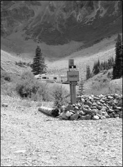 |
| Carroll hopes the trail inventory will help prevent
this kind of situation on the abundance of mining
claims around Silverton. /Photo by Amy Maestas. |
creating a map for recreation
users. On it, Carroll and his group will carefully mark
existing trails and their accepted usages. Although the project
is
in its nascent stage, Carroll anticipates that the map
also will provide details about each trail, including descriptions
and a technical rating. Because so many trails start
at more
than 10,000 feet and climb many more thousands of feet,
Carroll and others guess that most trails will be rated on
the more
difficult end of the scale. In other words, this network
of trails may produce some of the most extreme hiking
and mountain biking in the region.
Property rights prevail
Currently, most of the public-lands trails in San Juan
County are unmapped because the Forest Service or BLM
have not officially
designated them, says Richard Speegle, recreation planner
for the Columbine Ranger District.
The agencies place trails or roads on their maps only
if they have official numbers. Speegle says the trail
situation
in San Juan County is particularly complex because much
of the public land exists in patchworks among mining
claims.
Thus, public land officials have never kept records of
what exists. Since the mining industry in Silverton went
belly
up, most companies are selling mining claims to individuals
who sometimes want to build homes or cabins on the property.
Because some trails end up crossing private property,
Speegle says more trails will be broken up and the possibility
of
creating a network made much harder.
“
It’s tough to designate a trail that goes through someone’s
property,” he says. “We are sensitive to private
land ownership.”
Speegle says that the BLM and Forest Service do have
a travel management plan that designates usage for each
mapped trail,
but the plan has not been updated since 1986, and it
largely addresses motorized travel. Carroll’s project, he adds,
will be the first of its kind in the county. However, Speegle
also says he isn’t familiar enough with Carroll’s
project to comment on its benefits. “But we would look
at his inventory of trails because we are always interested
in what people come up with,” he said.
Polishing reputations
Meanwhile, some Silverton business owners believe Carroll’s
map will boost their business reputation. They are unsure
how much it will impact tourism, if at all.
Douglas Wall, a partner of the year-old Explorer’s
Club: Southwest, a self-styled guide service, pub and grill,
says visitors often inquire at businesses about places to
hike or bike. Because of the popular Alpine Loop, Jeep trails
are mostly well marked and used. Nonmotorized recreationalists,
however, have less direction about where to go.
“
We have people coming in all the time wanting (this information),” Wall
says.
Wall adds that more information is always helpful, especially
for his business, but he’s hesitant to attribute additional
visitors to a map like Community Design’s.
“
I think the greater impact will be the reputation of existing
business, because we’ll be able to give them what they
want,” he said. “I don’t know if more people
will actually come here because of a map.”
Carroll, too, is unsure if the San Juan Trails Initiative
will boost tourism. It’s likely, he says, but it’s
not the sole intent.
“
If the map is adopted and implemented by the BLM and Forest
Service, I think it would have significant tourist and economic
impacts that could more than rival the (Durango & Silverton
Narrow Gauge Railroad) train’s numbers,” he says. “Most
interesting is, this would be an environmentally clean economic
impact.”
Community outreach
Field work, which entails using GPS units to mark points
for map information, along with biological studies, is
just beginning. Carroll is relying on graduate students
studying
environmental planning and landscape ecology to do the
bulk of the work, which he expects will begin in earnest
next
spring.
Right now, funding is coming from $70,000 of seed money
donated to Community Design by Carroll, some of his previous
clients
and private donors. Carroll says the group is considering
applying for a grant from Great Outdoors Colorado, but
even without government funding, the group has enough
money right
now to cover the project for the next two years.
In addition, Community Design is receiving technology
support and lab infrastructure from Auburn University’s College
of Architecture, Design and Construction in Alabama. Auburn
is associated with Community Design and its projects because
Carroll is an alumnus and because of his work with the late
Samuel Mockbee, a landscape architect famous for his work
on environmental and affordable housing projects.
With secured funding, Carroll expects the group’s chief
obstacle to be continuity of trails. Mining companies are
rapidly selling claims to people, some who build on the property,
blocking access to existing trails. Since historically the
trails have been open to the public, Carroll says his group
will be challenged to work with property owners to restore
or secure access.
“
We certainly want to identify reroutes in a nonadversarial
manner,” he says. “We don’t want to be
going to court. We want to go to people and ask how we can
work together.”
This is also part of Carroll’s attempt to keep “politics” from
upending the project. His goal, he says, is to offer the
community and its visitors a resource that at the least will
be a record of mining history and at best a guide to some
of the most sought-out terrain in the country.
“
What we have here is a real jewel,” says Carroll.